

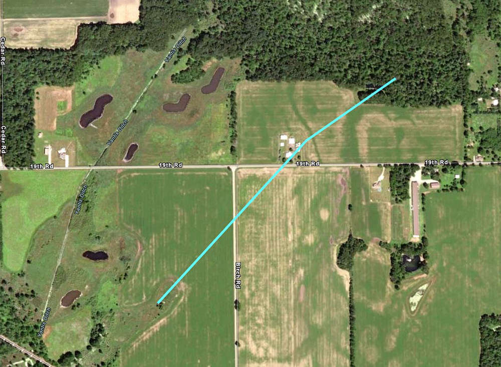
The National Weather Service in Northern Indiana confirmed an EF0 tornado struck the rural area southeast of Tippecanoe just past midnight Tuesday.
At approximately 12:09 AM on Tuesday, July 16, a weak tornado touched down in agricultural land south of 19th Road and west of Birch Road. The tornado crossed near the 19th/Birch intersection, caused damage to a residential property on 19th Rd, and then passed through another farm field and into a wooded area before lifting at 12:11 AM.
Damage was confined to several trees being snapped or uprooted in the area. Additional damage continued northeast to along Apple Road but appeared to be from straight line winds, rather than a tornado.
The length of the tornado’s path was 0.7 miles, and its width was 75 yards. Maximum winds are estimated at 75 mph, which classifies it as EF0.
This information is preliminary and subject to change pending final review of the event.
While all of Marshall County experienced severe wind speeds in Monday night/Tuesday morning’s line of storms, this area was the only place where damage appeared to be caused by a tornado and not straight-line winds.
The damage survey was a joint effort of the National Weather Service, the Marshall County Emergency Management Agency, and the Marshall County Sheriff’s Department.
A map of the tornado’s track is highlighted in blue below.
 Rep. Greene recognized for Statehouse efforts by autism advocacy groups
 Ray Allison named next executive director of the Indiana State Fair Commission
 Another record-breaking season at Horseshoe Indianapolis
 INvestABLE Indiana announces expanded eligibility criteria beginning January 1
 Governor Braun announces record year for Indiana tourism
 Indiana's state parks offer New Years Day events
 Indiana casinos see revenue dip in November
 City interested in purchasing land for second downtown parking garage