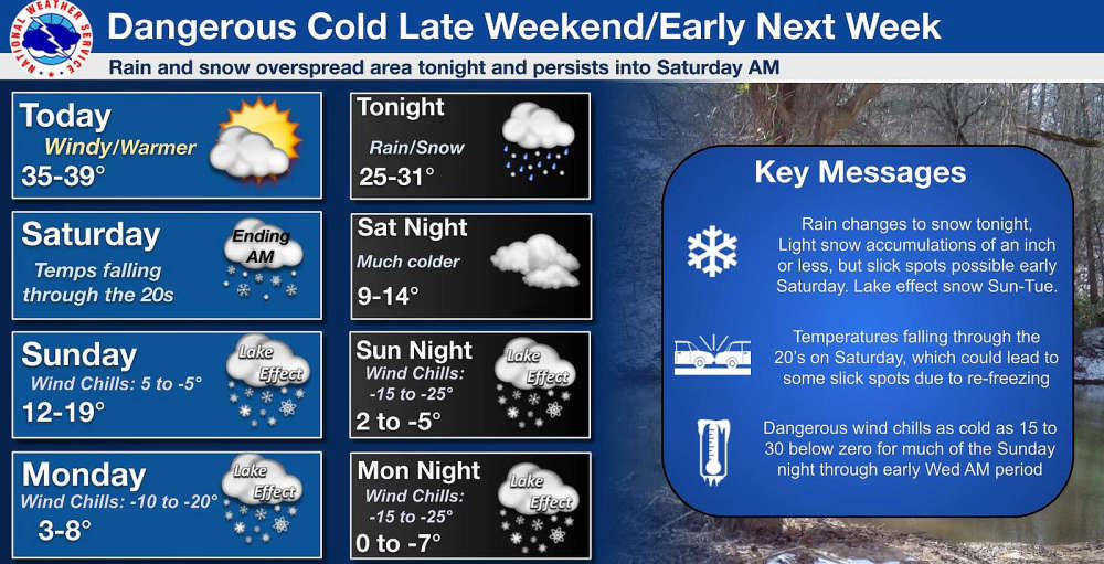
Extremely cold temperatures will settle into the region early next week, bringing dangerous wind chills.
Temperatures start falling on Saturday, with wind chills below zero beginning Sunday afternoon. Lows on Monday, Tuesday, and Wednesday morning will be around -25 wind chills. Little relief is expected during daytime hours, as it isn't expected to get any warmer than -10 on Monday or -15 on Tuesday/Wednesday.
Marshall County Emergency Management Agency Director Jack Garner advises schools to monitor wind chills carefully, considering delays and even a shift to E-Learning/closures, depending on the school’s procedures.
The city and towns in the county will have warming centers available. In the event of widespread issues, Marshall County EMA will coordinate with communities to open larger facilities.
Citizens should take preventive measures, such as allowing faucets to drip, insulating pipes, and dressing as warm as possible. They should also check on vulnerable neighbors, friends, and family. With these extreme wind chills, frostbite can occur rapidly.
 Shelby County Sheriff warns of another scam in the area
 Safe Zones enforcement to resume on I-70 in Hancock Co., begin on I-65 in Jasper Co.
 Class 2A, No. 6 Triton Central tops Scecina for second consecutive sectional title
 IDHS focuses on raising awareness during Severe Weather Preparedness Week, March 8-14
 Teens on electric bikes riding in traffic arrested by McCordsville Police
 United States Attorney’s Office Southern District of Indiana lists federal immigration prosecutions, one from Bartholomew Co.
 Penny-rounding for retailers
 Chris Holder named by Republican caucus to serve as Shelby County Sheriff