

indot-prepares-for-ice-and-freezing-rain-impacts-to-tuesday-morning-commutes-possible
The Indiana Department of Transportation is preparing for a a period of freezing rain and wintry mix expected to impact a large portion of state starting Monday afternoon through Tuesday morning.
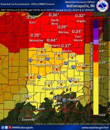
The National Weather Service (NWS) has issued winter weather advisories for all counties north of Seymour. NWS is calling for around 0.1" of ice, with amounts as high as 0.3" or more north of I-70.
INDOT will be at a full call in most areas, with nearly 1,000 trucks treating state highways, interstates and U.S. routes by Monday evening. Trucks will remain active for the duration of the ice event and afterward to continue cleanup efforts.
Freezing rain is expected to begin Monday afternoon and continue through early Tuesday, transitioning to rain across the state by mid-day. Areas north of Lafayette may also see light snow.
Slick conditions are expected, with possible impacts to morning commutes on Tuesday. Motorists should closely monitor forecasts and avoid unnecessary travel. Those who must travel should expect ice accumulation, especially on elevated surfaces such as bridges and overpasses.
Drivers should remember to slow down, increase following distance, allow extra travel time and give plow trucks room to work.
Monitor real-time travel conditions and view traffic and snow plow cameras online at 511in.org or via INDOT's TrafficWise app. Regular updates will also be shared on INDOT's social media channels. Check for travel advisories in your area at in.gov/dhs/traveladvisory.
 Putnam County Day of Service seeks volunteers
 Indiana state forests to offer open houses
 HEALTHFEST coming to Putnam County this weekend
 Putnam County schools receive school safety funds
 Former Roachdale Town Marshal sentenced to probation
 Putnam County man rescued from grain bin
 United Way of Central Indiana launches statewide health plan to strengthen human services nonprofits
 DePauw details free tuition offer for families making up to $100,000

